

The City of Calgary Land Use Bylaw 1P2007
Top of page
PART 14: MIXED USE DISTRICTS
Division 1: General Rules for Mixed Use Land Use Districts
Purpose
1333
The mixed use districts are intended to:
f
promote residential development: designed to be compatible with active, street-oriented commercial uses; and
Projections Into Setback Areas
1334
1
Unless otherwise referenced in subsections (3) (4), (5), (6), (7), (8) and (9) a building or air conditioning units must not be located in any setback area.
2
Portions of a building located above the surface of the ground may project into a setback area only in accordance with the rules contained in this section.
3
Portions of a building below the surface of the ground may extend without any limits into a setback area.
5
Eaves may project a maximum of 0.6 metres, and window wells may project a maximum of 0.8 metres, into any setback area.
6
Landings not exceeding 2.5 square metres, ramps other than wheelchair ramps and unenclosed stairs may project into any setback area.
7
Where a parcel shares a property line with another parcel, air conditioning units may project a maximum of 1.5 metres into the setback area at the shared property line.
8
Signs may be located in any setback area, and where so located, must be in accordance with Part 3, Division 5.
Building Separation
1335
1
Where the widest dimension of a balcony faces a property line shared with another parcel, the minimum setback of a balcony from the shared property line is 4.0 metres.
2
The façade of a building located above 23.0 metres from grade must provide a minimum horizontal separation of:
Window Separation
1336
Each unit must have at least one window or door with a glazed area with a minimum dimension of 1.0 metre that provides an unobstructed outdoor view to a minimum depth of 6.0 metres measured perpendicular to the middle of the glazed area.
Ground Floor Height
1337
1
Unless otherwise referenced in subsection (2), the minimum height of the ground floor of a building is 4.0 metres as measured vertically from the floor to the ceiling.
Street Wall Stepback
1338
Where the height of a building is greater than 23.0 metres measured from grade, the façade of the building within 6.0 metres of a property line shared with a street must have a horizontal separation from the portion of the façade closest to grade such that:
b
the horizontal separation occurs between a minimum of 7.5 metres and a maximum of 23.0 metres measured from grade.
Rules for Façades Facing a Street
1340
1
The length of the building façade that faces the commercial street must be a minimum of 80.0 per cent of the length of the property line it faces.
2
In calculating the length of the building façade, the depth of any required rear or side setback areas will not be included as part of the length of the property line.
3
Lobbies or entrances for upper floor uses must not occupy more than 20% of the at grade façade facing a street. For laneless parcels, portions of façades dedicated to underground parking and loading entrances must not be included as part of the at grade façade for the purposes of this rule.
Rules for Dwelling Units Facing a Street
1341
1
An entrance to an individual Dwelling Unit located at grade must be setback a minimum of 2.5 metres from a property line shared with a street.
2
The minimum height of the main floor of any portion of a Dwelling Unit located less than 3.0 metres from a property line shared with a street is 0.6 metres above grade.
Rules for Commercial Uses Facing a Street
a
occupy a minimum of 65.0 per cent of the façade between a height of 0.6 metres and 2.4 metres; and
2
Where the façade of a building contains a Dwelling Unit, that portion of the façade is not required to meet the requirements of subsection (1).
General Landscaped Area Rules
1344
1
Landscaped areas must be provided in accordance with a landscape plan approved by the Development Authority.
2
A landscape plan for the entire development must be submitted as part of each development permit application where changes are proposed to the building or parcel, and must show at least the following:
c
the layout of berms, open space systems, pedestrian circulation, retaining walls, screening, slope of the land, soft surfaced landscaped area and hard surfaced landscaped areas;
d
the types, species, sizes and numbers of plant material and the types of hard surfaced landscaped areas;
f
for landscaped areas with the Low Water Landscaping Option details of the low water irrigation system, including extent of water delivery; and
g
for landscaped areas with a building below, the following additional information must be provided:
3
The landscaped areas shown on the landscape plan approved by the Development Authority must be maintained on the parcel for so long as the development exists.
4
All soft surfaced landscaped area must be irrigated by an underground irrigation system, unless otherwise provided by a low water irrigation system.
Planting Requirements
2
Deciduous trees must have a minimum calliper of 50 millimetres and at least 50.0 per cent of the provided deciduous trees must have a minimum calliper of 75 millimetres at the time of planting.
3
Coniferous trees must have a minimum height of 2.0 metres and at least 50.0 per cent of the provided coniferous trees must be a minimum of 3.0 metres in height at the time of planting.
5
For landscaped areas with a building below, planting areas must have the following minimum soil depths:
Additional Landscaping Requirements
1347
1
Unless otherwise referenced in a District, all areas on a parcel, not including those portions specifically required for motor vehicle access, sidewalks, or any other purpose allowed by the Development Authority, must be a soft surfaced landscaped area.
2
A public sidewalk must be located along the entire length of each property line shared with a street.
3
Every building on a parcel must have at least one sidewalk connecting the public entrance to a public sidewalk.
4
Where a building contains more than one use, every use that has an exterior public entrance must either:
5
Every building on a parcel must have at least one sidewalk connecting the parking area to the public entrances of the building.
ii
1.5 metres for a sidewalk providing access to a shared residential entrance or more than one unit; or
Landscaping in Setback Areas
1348
1
Where a setback area shares a property line with another parcel designated as a residential district, the setback area:
2
Where a setback area shares a property line with a lane, the portion of the setback area not required for access from the lane must be landscaped with a soft surface landscaped area and may include a sidewalk.
Residential Amenity Space
1349
1
Amenity space may be provided as common amenity space, private amenity space or a combination of both.
3
When the private amenity space provided is 5.0 square metres or less per unit, that specific area will be included to satisfy the amenity space requirement.
4
When the private amenity space exceeds 5.0 square metres per unit, only 5.0 square metres per unit must be included to satisfy the amenity space requirement.
c
must have a contiguous area of not less than 50.0 square metres, with no dimension less than 6.0 metres.
8
Common amenity space — outdoors must provide a balcony, deck or patio and at least one of the following as permanent features:
Excess Motor Vehicle Parking Stalls
1351
Where the number of motor vehicle parking stalls provided for uses, not including Dwelling Units or Live Work Units, is in excess of 6.0 stalls per 100.0 square metres of gross usable floor area, those excess stalls must be located in either underground or structured parking.
Reduction for Transit Supportive Development
1352
The required number of motor vehicle parking stalls in section 1350 is reduced by 25.0 per cent for a development on a parcel located within:
Reduction for Bicycle Supportive Development
1354
The total number of motor vehicle parking stalls required by section 1350 for all of the units within the development is reduced by 0.25 motor vehicle parking stalls for each additional bicycle parking stalls — class 1 provided in excess of the number of bicycle parking stalls — class 1 required in section 1353 to a maximum of 25 per cent of the total number of motor vehicle parking stalls required by section 1350 for all of the units within the development.
Vehicle Access
1355
1
Unless otherwise referenced in subsections (2) and (3), where the parcel shares a rear property line or side property line with a public lane, all vehicle access to the parcel must be from the public lane.
3
Motor vehicle parking stalls and loading stalls must not be located between a building and a street.
Recycling Facilities
1359
Recycling facilities must be provided for every development containing Dwelling Units.
Mechanical Screening
1360
Mechanical systems or equipment located outside of a building shall be positioned, camouflaged or screened from view of a public space, or from view of a parcel designated as a residential district, located within 30.0 metres of the equipment, using a line of sight of 1.7 metres above grade.
Visibility Setback
1361
Within a corner visibility triangle, buildings, fences, finished grade of a parcel and vegetation must not be located between 0.75 metres and 4.6 metres above the lowest elevation of the street.
Fences
a
1.2 metres for that portion of the fence extending beyond the foremost portion of all buildings on the parcel;
b
2.0 metres for that portion of the fence that does not extend beyond the foremost portion of all buildings on the parcel; and
c
2.5 metres to the highest point of a gateway, provided that the gateway does not exceed 2.5 metres in length.
Division 2: Mixed Use - General (MU-1f#h#d#) District
Purpose
2
The Mixed Use — General District should only be located where a local area plan, or other policy, supports land use and development aligned with the purpose statements in subsection (1).
Permitted Uses
2
The following uses are permitted uses in the Mixed Use — General District if they are located within an existing approved building:
2.1
The following uses are permitted uses in the Mixed Use — General District if they are located within existing approved buildings and if the public area is 150.0 square metres or less:
3
The following uses are permitted uses in the Mixed Use — General District if they are located within an existing approved building and are not located on the ground floor:
Discretionary Uses
1367
1
Uses listed in subsections 1366(2) and (3) are discretionary uses if they are located in proposed buildings or proposed additions to existing buildings in the Mixed Use — General District.
1.1
The following uses are discretionary uses in the Mixed Use — General District if they are located within existing approved buildings and if the public area is greater than 150.0 square metres.
1.2
The following uses are discretionary uses in the Mixed Use — General District if they are located in proposed buildings or proposed additions to existing buildings:
2
Uses listed in subsection 1366(3) are discretionary uses in the Mixed Use — General District if they are located on the ground floor of an existing approved building.
Floor Area Ratio
2
The maximum floor area ratio for parcels designated MU-1 is the number following the letter "f" indicated on the Land Use District Maps.
Building Height
1371
1
Unless otherwise referenced in subsections (2), (3) and (4), the maximum building height is the number following the letter "h" when indicated on the Land Use District Maps.
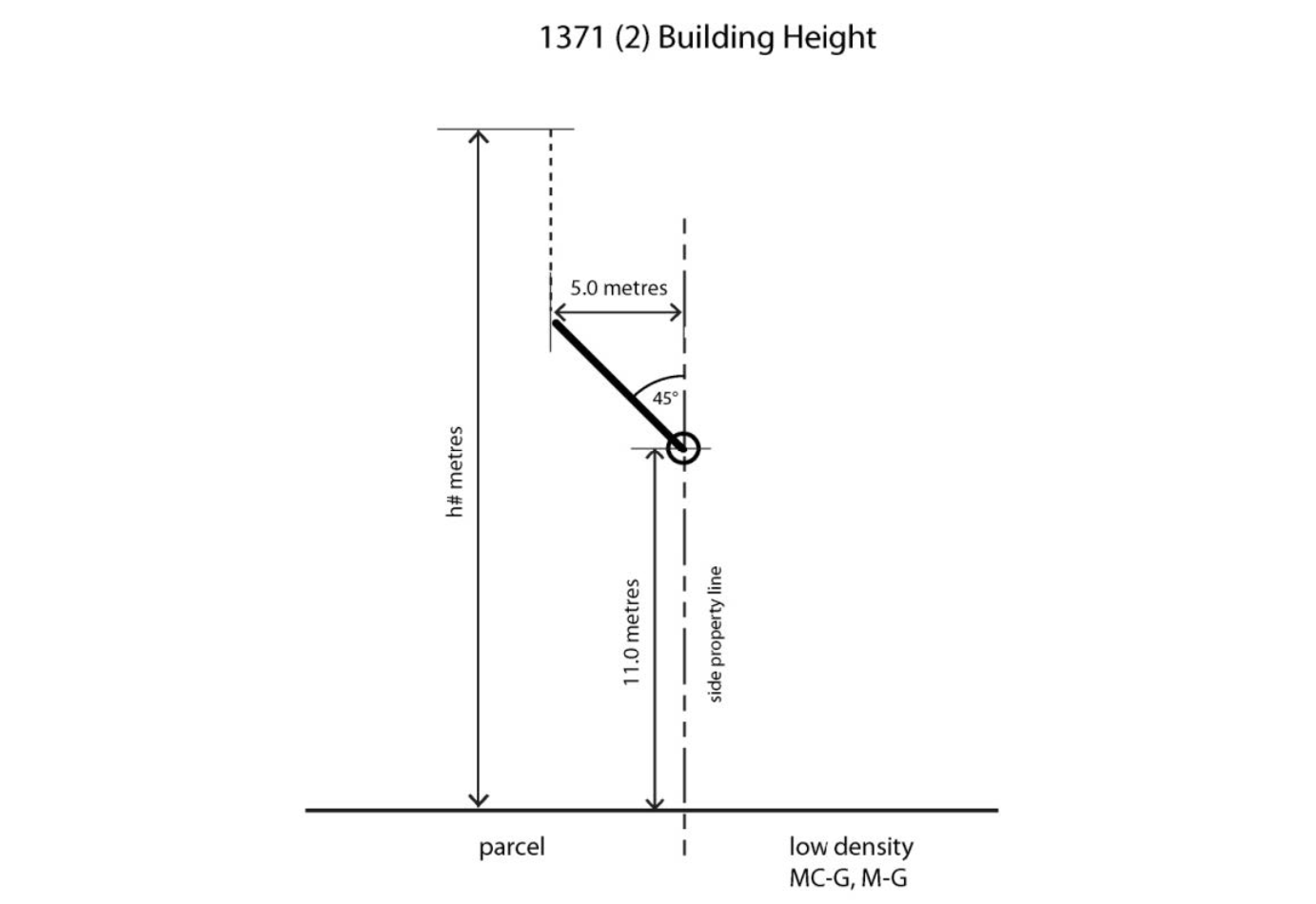
2
Where the parcel shares a side property line with a parcel designated as a low density residential district, H-GO, M-CG or M-G District the maximum building height:
b
increases at a 45 degree angle to a depth of 5.0 metres from the shared property line or to the number following the letter "h" indicated on the Land Use District Maps, whichever results in the lower building height; and
c
increases to the number following the letter "h" indicated on the Land Use District Maps measured from grade at a distance greater than 5.0 metres from the shared property line.
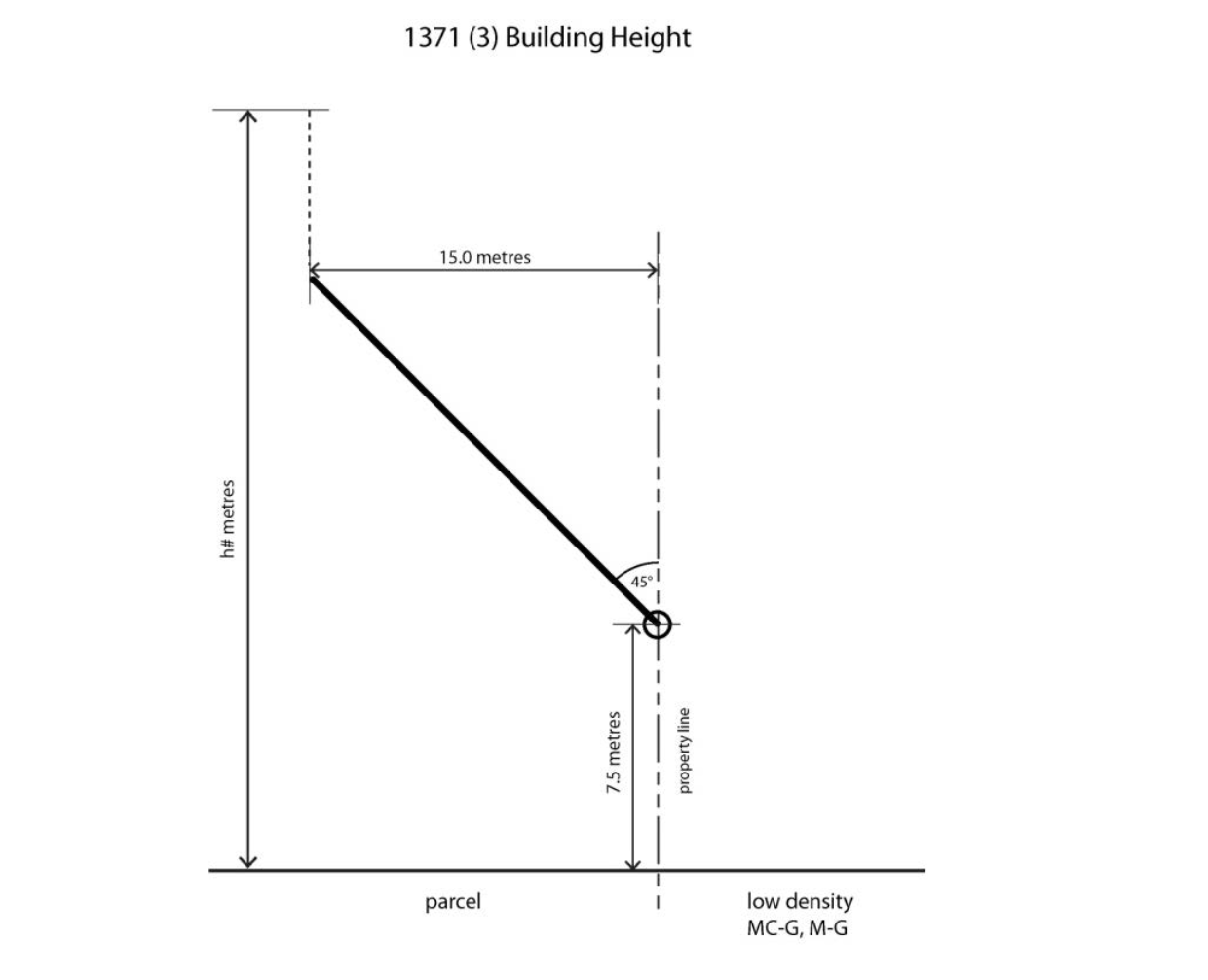
3
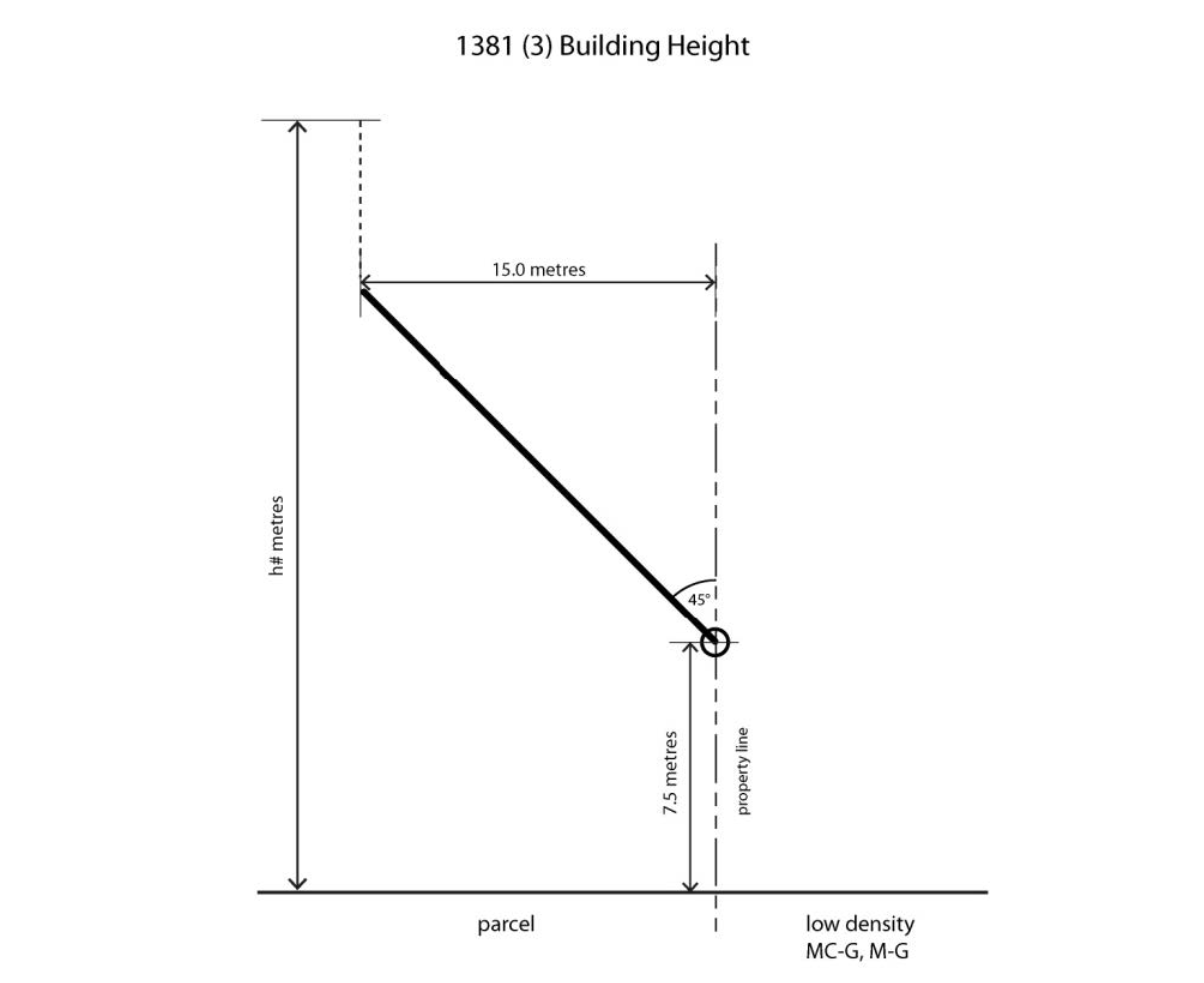
Where the parcel shares a rear property line with a parcel designated as a low density residential district, H-GO, M-CG or M-G District the maximum building height:
b
increases at a 45 degree angle to a depth of 15.0 metres from the shared property line or to the number following the letter "h" indicated on the Land Use District Maps measured from grade, whichever results in the lower building height; and
c
increases to the number following the letter "h" indicated on the Land Use District Maps measured from grade at a distance greater than 15.0 metres from the shared property line.
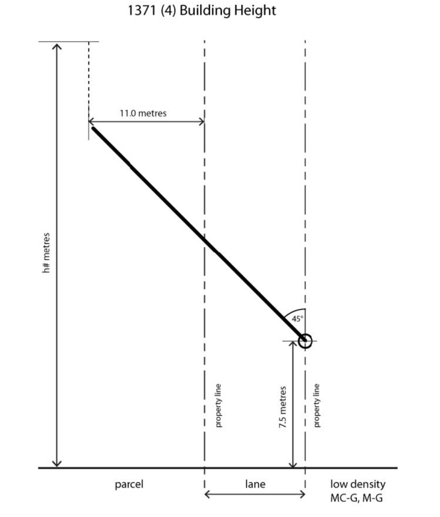
4
Where the parcel shares a property line with a lane that separates the parcel from a parcel designated as a low density residential district, H-GO, M-CG or M-G District the maximum building height:
a
is 7.5 metres measured from grade at the property line that the parcel designated as a low density residential district, H-GO, M-CG or M-G District shares with the lane;
b
increases at a 45 degree angle to a depth of 11.0 metres from the property line shared with the lane or to the number following the letter "h" indicated on the Land Use District Maps, whichever results in the lower building height measured from grade; and
c
increases to the number following the letter "h" indicated on the Land Use District Maps measured from grade at a distance greater than 11.0 metres from the property line shared with the lane.
Use Area
1372
1
The maximum use area of a Catering Service — Minor, or a Catering Service — Minor combined with any other use, is 300.0 square metres.
2
The maximum public area for a Restaurant: Food Service Only or Restaurant: Licensed is 300.0 square metres.
Façade Width for Uses Facing a Street
1373
1
Unless otherwise referenced in subsections (2) and (3), the length of the building façade that faces a street containing an individual use on the floor closest to grade is a maximum of 15.0 metres.
2
For an individual Drinking Establishment — Small, Restaurant: Food Service Only, Restaurant: Licensed, Retail and Consumer Service or Supermarket use located on the floor closest to grade, the length of the building façade that faces a street may be increased to 30.0 metres where all of the other uses that share the same façade meet the requirements of subsection (1).
3
The length of the building façade that faces a street containing an individual Health Care Service, Financial Institution, or Office use on the floor closest to grade is a maximum of 9.0 metres.
Setback Area
1374
1
Where a parcel shares a property line with a parcel designated as a low-density residential district, H-GO, M-CG or M-G:
b
with a lane that separates the parcel from a parcel designated as a residential district or mixed use district, the setback area must have a minimum depth of 7.5 metres measured from the property line that the adjacent parcel designated as a residential district or mixed use district shares with the lane; and
3
For the storey closest to grade, the maximum building setback from a property line shared with a street is 4.5 metres for 60 per cent of the length of the building façade that faces the street.
Illustration 10:
Building Height in the Mixed Use — General (MU-1) District.
Division 3: Mixed Use - Active Frontage (MU-2f#h#d#) District
Purpose
2
The Mixed Use - Active Frontage District should only be located where a local area plan, or other policy, supports land use and development aligned with the purpose statements in subsections (1).
Permitted Uses
2
The following uses are permitted uses in the Mixed Use - Active Frontage District if they are located within existing approved buildings:
2.1
The following uses are permitted uses in the Mixed Use — Active Frontage District if they are located within existing approved buildings and if the public area is 150.0 square metres or less:
3
The following uses are permitted uses in the Mixed Use — Active Frontage if they are located within an existing approved building and are not located on the ground floor:
Discretionary Uses
1377
1
Uses listed in subsections 1376(2) and (3) are discretionary uses if they are located in proposed buildings or proposed additions to existing buildings in the Mixed Use - Active Frontage District.
1.1
The following uses are discretionary uses in the Mixed Use — Active Frontage District if they are located within existing approved buildings and if the public area is greater than 150.0 square metres.
1.2
The following uses are discretionary uses in the Mixed Use — Active Frontage District if they are located in proposed buildings or proposed additions to existing buildings:
2
Uses listed in subsection 1376(3) are discretionary uses in the Mixed Use - Active Frontage District if they are located on the ground floor of an existing approved building.
Floor Area Ratio
2
The maximum floor area ratio for parcels designated MU-2 is the number following the letter "f" indicated on the Land Use District Maps.
Building Height
1381
1
Unless otherwise referenced in subsections (2), (3) and (4), the maximum building height is the number following the letter "h" when indicated on the Land Use District Maps.
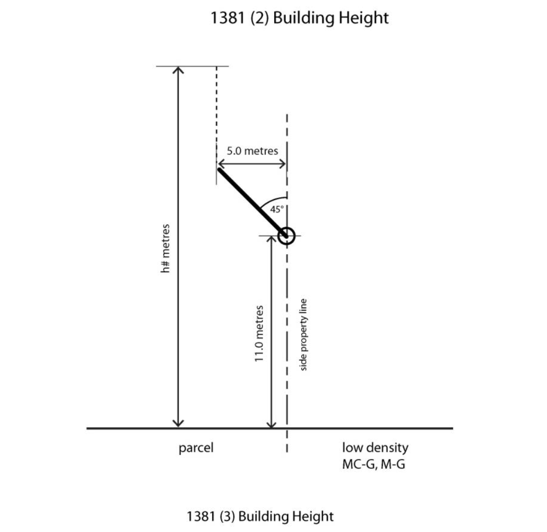
2
Where the parcel shares a side property line with a parcel designated as a low density residential district, H-GO, M-CG or M-G District the maximum building height:
b
increases at a 45 degree angle to a depth of 5.0 metres from the shared property line or to the number following the letter "h" indicated on the Land Use District Maps, whichever results in the lower building height; and
c
increases to the number following the letter "h" indicated on the Land Use District Maps measured from grade at a distance greater than 5.0 metres from the shared property line.
3
Where the parcel shares a rear property line with a parcel designated as a low density residential district, H-GO, M-CG or M-G District the maximum building height:
b
increases at a 45 degree angle to a depth of 15.0 metres from the shared property line or to the number following the letter "h" indicated on the Land Use District Maps measured from grade, whichever results in the lower building height; and
c
increases to the number following the letter "h" indicated on the Land Use District Maps measured from grade at a distance greater than 15.0 metres from the shared property line.
4
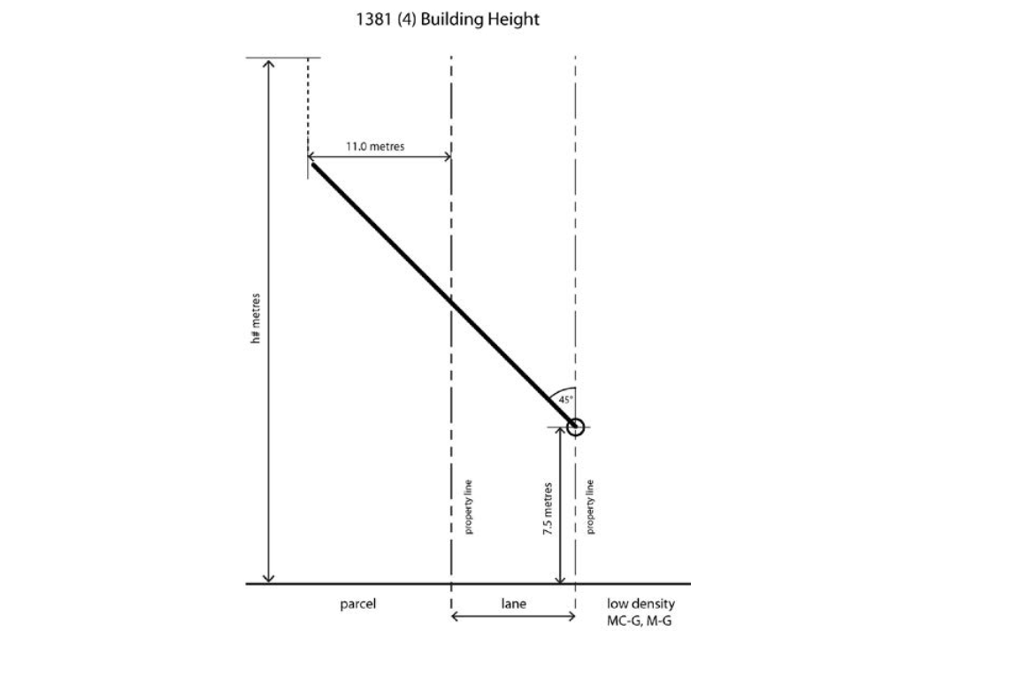
Where the parcel shares a property line with a lane that separates the parcel from a parcel designated as a low density residential district, H-GO, or M-CG District the maximum building height:
a
is 7.5 metres measured from grade at the property line that the parcel designated as a low density residential district, H-GO, M-CG or M-G District shares with the lane;
b
increases at a 45 degree angle to a depth of 11.0 metres from the property line shared with the lane or to the number following the letter "h" indicated on the Land Use District Maps, whichever results in the lower building height measured from grade; and
c
increases to the number following the letter "h" indicated on the Land Use District Maps measured from grade at a distance greater than 11.0 metres from the property line shared with the lane.
Use Area
1382
1
The maximum use area of a Catering Service — Minor, or a Catering Service — Minor combined with any other use, is 300.0 square metres.
2
The maximum public area for a Restaurant: Food Service Only or Restaurant: Licensed is 300.0 square metres.
Façade Width for Uses Facing a Street
1384
1
Unless otherwise referenced in subsections (2) and (3), the length of the building façade that faces a street containing an individual use on the floor closest to grade is a maximum of 15.0 metres.
2
For an individual Drinking Establishment — Medium, Drinking Establishment — Small, Restaurant: Food Service Only, Restaurant: Licensed, Retail and Consumer Service or Supermarket use located on the floor closest to grade, the length of the building façade that faces a street may be increased to 30.0 metres where all of the other uses that share the same façade meet the requirements of subsection (1).
3
The length of the building façade that faces a street containing an individual Health Care Service, Financial Institution, Office or Payday Loan use on the floor closest to grade is a maximum of 9.0 metres.
Setback Area
1385
1
Where a parcel shares a property line with a parcel designated as a low-density residential district, H-GO, M-CG or M-G:
b
with a lane that separates the parcel from a parcel designated as a residential district or mixed use district, the setback area must have a minimum depth of 7.5 metres measured from the property line that the adjacent parcel designated as a residential district or mixed use district shares with the lane; and
3
For the storey closest to grade, the maximum building setback from a property line shared with a street is 4.5 metres for 60 per cent of the length of the building façade that faces the street.
Illustration 11:
Building Height in the Mixed Use — Active Frontage (MU-2) District