Traffic Management Centre TMC
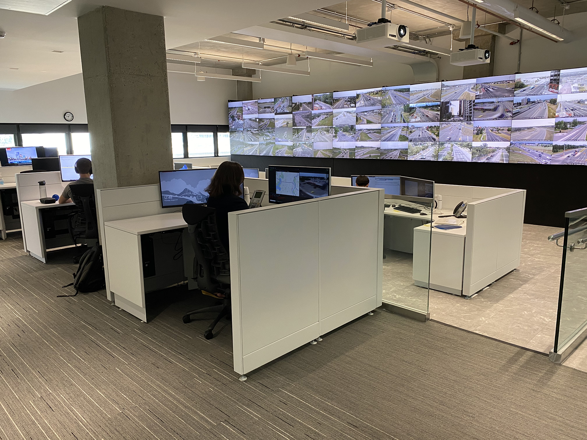
TMC Traffic Management Centre
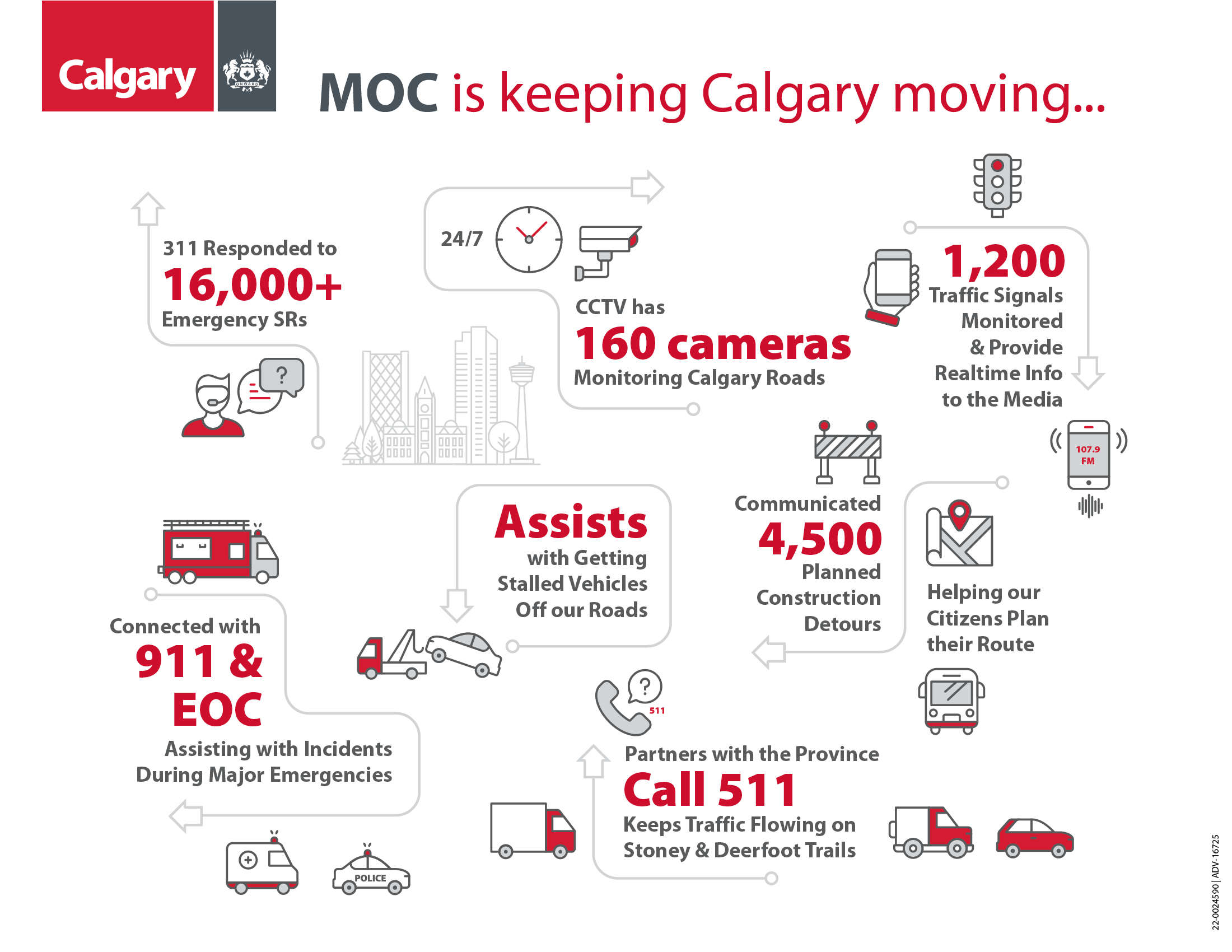
Advance traffic monitoring, incident management, traffic operation efficiency and traveler information.
Managing downtown traffic during construction
Calgary.ca/PlanYourTripThe City's Traffic Management Centre (TMC) monitors, responds and presents real-time information with the use of:
- Traffic cameras to monitor traffic flow, road conditions and traffic obstructions.
- Traffic systems to monitor and control the operation of traffic signals.
- A website map that shows road closures, road works and other activities impeding traffic flow.
- A FM radio station delivering current traffic information.
- Dynamic road signs to inform motorists of traffic problems.
- Travel time Technology
- Lane reversals.
- High Occupancy Vehicle (HOV) lanes
This combination of technologies gathers real-time traffic information and uses that information to revise traffic signal operation where appropriate and keep motorists advised of abnormal traffic conditions, congestion, lane closures and construction delays.
-
Details on road construction, road closures, detours, accidents and incidents that may affect your commute.
-
View up-to-the-minute traffic camera images of current road conditions on major routes as well as other key intersections.
-
Current travel times when traveling by a vehicle between various points within the city.
-
Watch and see how we keep Calgarians moving year round.


Frequently Asked Questions
How does the Traffic Management Centre (TMC) coordinate signals on major roadways?
Major road corridors within the city of Calgary are coordinated. Traffic signals are coordinated to give priority to the heaviest one-way movement, for example, towards Downtown during the morning rush hour and out of Downtown during the evening rush hour.
Learn more:
- Traffic signal timing and coordination
- Report damaged traffic signals
- Request a new traffic or left turn signal
When is the coordination of signals most disrupted?
Coordination is temporarily interrupted by emergency vehicles (such as fire vehicles, LRT travel and routes times and transit priority calls). During such instances, traffic signals will enter transition mode and have disrupted coordination. A transition period can last up to 10 minutes.
How does traffic signal timing work?
Signal timing plans are created for the busiest part of the peak time, when there would be the largest volume of demand. If there is low side street volume at an intersection, the main street may turn green earlier than expected.
Learn more:
- Traffic signal timing and coordination
- Report damaged traffic signals
- Request a new traffic or left turn signal
Does the Waze app work to plan routes for cyclists and pedestrians as well as vehicles?
Waze is designed exclusively for vehicles only. This limitation is set by Waze and is not something the Traffic Management Centre (TMC) can change.
For pedestrians, the TMC may extend the duration of the walk signal, especially when the vehicular green phase is long.
For cyclists, if dedicated signals are in place, the TMC assess their operation during detours to ensure a consistent level of service.
To learn more about how The City’s Mobility programs support traffic flow safety for drivers, pedestrians, cyclists and more.
Why is The City’s Traffic Management Centre (TMC) supporting the use of Waze over Google Maps?
The key difference is that the TMC can update construction and incident information in real time directly to Waze, which is not possible with Google Maps. For example, the TMC manually posts and clears major events on Waze - such as the start and end of the Stampede Parade. So, if a planned event ends earlier than scheduled, we can quickly update the end time, and the closure is immediately removed from the map. This ensures drivers can get the most current and accurate information.
Go to Calgary.ca/PlanYourTrip to download the Waze app
Does The City share construction detail with Waze to help drivers plan ahead?
Yes. The Traffic Management Centre (TMC) pushes City-lead construction project information directly to Waze, allowing the app to regularly update its routing based on the latest data. This level of integration is not available with Google Maps. While Google Maps does pull data from Waze, we typically observe a delay before those updates appear in Google Maps.
Does the collaboration with Waze include managing major road traffic so it doesn’t divert drivers through residential neighbourhoods?
There is a possibility that Waze may route drivers through local neighbourhood streets; however, this is not something we encourage. Since our partnership began in 2021, The City has not received any major concerns from residents regarding Waze-related cut-through traffic flows or problems.
Go to Calgary.ca/PlanYourTrip to learn more about our work with Waze